The afternoon before, we had left Lawrie's Marina where First Contact had lay since arriving last November. The layover had been kind to her, being out of the cyclone belt and out of the extreme heat and humidity of the tropics. Now, the coconut oil had set, the covers were removed, and it was time to head north. We motored around to the duckpond at Mooloolaba to await the high tide.
At 02:15 we pulled up anchor and with a 5 knot SW wind gently blowing, made our way along the canals and past the marinas to the bar. The lights from the buildings ashore compensated for the moonless night, and the stars delineated sea from sky on the horizon. As forecast, the tide was nearing its height and the conditions dead flat. After clearing the bar, we put out the headsail and locked on the auto-helm for the 44nm run to Double Island Point. Colin went back to bed.
Around dawn the wind strengthened to 10 knots and went more south easterly; the wind right behind us. Along with the wind, and the change of tide, the seas started to develop quite a swell. The swell passing under the hull threatened to gybe the headsail, so we bore off about 5 to 10 degrees to get a better angle. Not long after dawn we cut the engine, with First Contact doing 5 knots along the rhumb line. At 1000 the wind strengthened again, this time to be around 10-15 knots, but the swell as we approached Double Island Point got quite vigorous. Overall the conditions made us think about the impending Wide Bay Bar crossing, and if it was going to be safe to do so. The next few hours were great for passage making - the boat averaging speeds of 5-6 knots SOG - but making us more and more concerned about being able to navigate safely over the bar.
We rounded Double Island Point and sidestepped Wolf Rock and made for the Wide Bay Bar seaward reference mark. We instantly felt a little better now the sea had been tamed by the headland. Clouds were starting to gather around the coast, and our sunny day started to take on an overcast and ominous complexion. We'd left Mooloolaba to make use of the high tide (0300) and needed to be at the Wide Bay Bar no later than 1500 if we were to make a crossing on a flooding tide, which was to end at 1600.
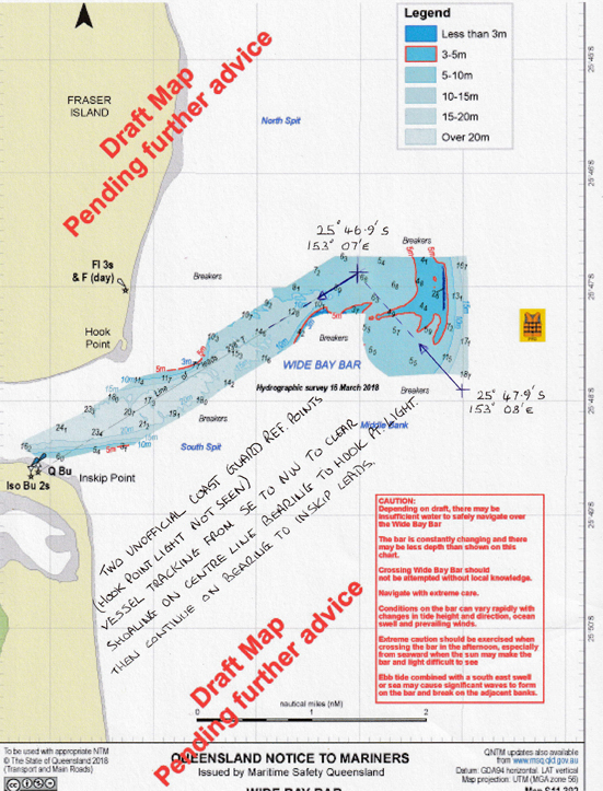
About five miles from the Wide Bay Bar Cameron called VMR Tin Can Bay to log on for the crossing and check the navigation data we had from our previous crossing in November 2017. The radio operator took our details and advised us there had been a substantial change to the recommended waypoints. He sent these new coordinates to our phone along with a visual map. In the six months since crossing the bar, the recommended track had shifted south and west of the previous coordinates.

Cameron quickly plotted the updated waypoints into the GPS and cross-checked, while Colin on the helm held First Contact into the oncoming waves until we were sure everything was right to commence the crossing. It was just after 1330 - we were an hour and a half ahead of our scheduled arrival, but carefully checking the tide we ascertained First Contact had more than enough water to safely cross. We donned life jackets.
WOW. What a ride. We activated the new route and the navigation data appeared at the helm. We lined up with reference point one and with our hearts in our mouths commence the run across the bar. By this stage, unhelpfully, the wind was up to 20 knots, but dead behind. The protection we had got from Double Island Point was gone. Swell of 1 to 1.5 meters was directly behind us and First Contact surged ahead at 6-7 knots into a rapidly shallowing sea. The depth dropped from 19 meters under the keel to 5 meters in a matter of moments - we had reached "Middle Bank." We had approximately 1.4nm on this course before turning to port to pick up the Inskip Point leads. A few huge waves picked us up from behind and we surfed down them. None of the broke on us, but there were breaking waves to port and starboard of us - and 4 meters of water under us. There were a few anxious moments and as we reached reference point 2 and commenced the turn to port, we were boarded by an oncoming wave which rode up the port freeboard and entered the cockpit, drenching Colin who was at the helm fighting to keep the boat true to her course in the washing-machine like seas. A quick towel down and we established our course onto Inskip Point leads. Ahead of us there were waves breaking to port and starboard, and in between these breakers was a patch of sea that wasn't breaking. It lined up with the lead markers, so that was our path in.
With the wind on the beam and a third of the headsail out in 20 knots, and the motor ticking over, riding the incoming tide, First Contact was doing 7.5 knots SOG. Depths improved on this leg known as "the mad mile" - which is actually 2.7nm - but the seas breaking around us where alarming. We passed through the boiling ocean and turned into the calm waters of the Great Sandy Straits as dark rain clouds let go their cargo seaward behind us.
With new found Sangfroid, we logged our successful and safe transit of the Wide Bay Bar with VMR Tin Can Bay and thanked them for their watch over us, and the updated information which saw us safely cross the bar in what were less than ideal conditions. As we'd arrived a few hours ahead of schedule, we motor sailed up to Gary's Anchorage on Fraser Island where we dropped anchor at 16:00 - just as the rain fell heavily onto the deck washing off all the salt we'd collected crossing the bar.
We made a couple of phone calls to let everyone know we were safe and well, and watched the sun go down over the mangroves eating corn chips and homemade hummus. A meal of homemade pumpkin soup, sourdough bread and a glass of wine was enough to send us to sleep feeling the anxiety of the day's activities melt into a calm recognition of achievement.
NORTH QUEENSLAND'S ANCHORAGE ENCYCLOPAEDIA
Discover The Coconut Coast: Anchorages of the Townsville, Cairns, Cooktown and Peninsula (Cape York) Coasts from Gloucester Island in the northern Whitsundays all the way north to Princess Charlotte Bay. Experience counts. Cruise with local knowledge.
